Skip to content
Dolce RoutesYour guide to Italy

Explore the guide

Home
My tripsRestore my saved trips
Across DolceRoutes

Find your
next guide.

Search the site’s city guides, itineraries and articles.

Explore DolceRoutes

Regions
Close this menu
My wishlist
Site naturel · Campania

Path of the Gods: Route, Difficulty & Return Transport

The Path of the Gods crosses the hills above the Amalfi Coast between Bomerano and Nocelle. CAI trail 327 covers 5.3 km of rocky paths, terraces and sea views. The descent to Positano comes afterwards: it is not included in those 5.3 km.

Piazza Paolo Capasso, Bomerano di Agerola 2–3 hours walking; half a day with breaks and transport Morning in spring or autumn, in settled weather Verified on 3 November 2026
Contents

Which guided Path of the Gods hike should you choose?

Group with an English-speaking guide par Positano.com · IAMME IA! / Gray Line

Guided hike from Sorrento with a stop at a shepherd's farm

⏱ 6½ hours including transfers
Pourquoi nous la recommandons

This 6½-hour outing includes transfers from a central Sorrento meeting point, an English-speaking guide and a light snack stop at a shepherd's farm. Lunch and hotel pick-up are not included. The exact meeting place appears on your confirmation. Cancellation is available up to 48 hours beforehand, subject to the booking terms; available dates are seasonal.

  • Return transfer from the Sorrento meeting point
  • Accompanied Path of the Gods hike
  • English-speaking walking guide
  • Light snack stop at a local shepherd's farm
Shuttle and walking poles par Positano.com · Buyourtour

Guided trek with shuttle and walking poles

⏱ 6 hours including transfers
Pourquoi nous la recommandons

This 6-hour option combines a return shuttle from Sorrento, an English- or Italian-speaking guide and the loan of walking poles. Pick-up is at your hotel or a nearby point accessible to the vehicle. Lunch is at your own expense. The tour runs seasonally, from spring through summer into autumn; cancellation is available up to 48 hours beforehand, subject to the booking terms.

  • Return shuttle from Sorrento
  • Walking guide in English or Italian
  • Loan of walking poles
  • Pick-up at your hotel or a nearby accessible point
Private vehicle and guide par Positano.com · Joe Banana Limos

Private day with driver, guide and lunch

⏱ Around 8 hours
Pourquoi nous la recommandons

This private day lasts about 8 hours and includes a vehicle with an English-speaking driver, a walking guide and lunch. The displayed amount is the minimum for a Sorrento departure; it varies with pick-up town and group size. Free cancellation ends seven days beforehand, subject to the terms. Confirm the walking guide's language when booking.

  • Private pick-up and return from the selected town
  • Air-conditioned vehicle with English-speaking driver
  • Private walking guide on the trail
  • Lunch in a family-run restaurant
From 1,176.00 €
View the private day trip

Which ticket to choose

I am already on the coast and walk independently

Free access, with outward and return transport planned

There is no trail admission ticket. Focus on getting to Bomerano and leaving Nocelle.

I am staying in Sorrento

A group outing with transfers

ST478 includes an English-speaking guide and a light snack; SZYEG offers English or Italian and walking poles. Neither option includes lunch.

We would like a private day trip

Vehicle, guide and lunch

The price depends on the departure point and number of participants; the minimum shown for Sorrento does not apply to every town.

I am travelling in winter

A planned independent walk or a guide available on my dates

Group excursions are seasonal. A lack of organised departures does not mean the path is closed; weather and local notices still determine whether you can walk it.

Days, opening times and prices

The trail has free access, with no ticket-office hours. Walk in daylight, with enough time to finish and catch your return transport. Maintenance, diversions and local restrictions can alter the route.

Before leaving, check the trail 327 information and map, then notices from Agerola and Positano. A GPS track saved well in advance does not replace waymarks and instructions on the ground.

Fermetures et exceptions

  • According to local notices and signs — Maintenance, diversions or restrictions on some sections · Follow the authorised route. Agerola's maintenance notice alone does not establish that the entire trail is closed.
  • During thunderstorms, heavy rain, strong winds or wildfire — Postpone the hike; local closure is possible · The trail has exposed sections; booking a guide does not guarantee the outing will go ahead.

Tarifs officiels

Walking access to the trailBuses, shuttles, ferries, guides and parking cost extra.0.00 €

Bomerano to Nocelle: start point, landmarks and trail map

The start is at Piazza Paolo Capasso in Bomerano, a hamlet of Agerola. Follow Via Pennino and signs for Sentiero degli Dei. The path passes Grotta del Biscotto and Colle la Serra, then continues towards Cannati and Nocelle, above Positano.

At Colle la Serra, a junction offers the 327 and 327a variants. They rejoin further on; do not confuse them with the longer upper route towards Santa Maria del Castello. The 327a is described as less exposed, which does not make it suitable for everyone afraid of heights.

The route described here ends in Nocelle. The steps towards Arienzo, the road towards Montepertuso and the descent to central Positano are extensions. To familiarise yourself with the route before setting out, use the CAI Monti Lattari map and keep it available offline.

5.3 km, 184 m ascent and 356 m descent: how demanding is it?

For CAI trail 327 from Bomerano to Nocelle, the reference sheet lists 5.3 km, a total ascent of 184 m and descent of 356 m. The path is therefore downhill overall, with real uphill stretches and steps between the two hamlets.

The CAI’s theoretical walking time is 2 hours. Allow 2–3 hours of walking for a sightseeing hike, then add stops, travel to Bomerano and the return from Nocelle. It soon becomes a half-day outing. Long photo stops or walking down to Positano require more time.

  1. Uneven ground

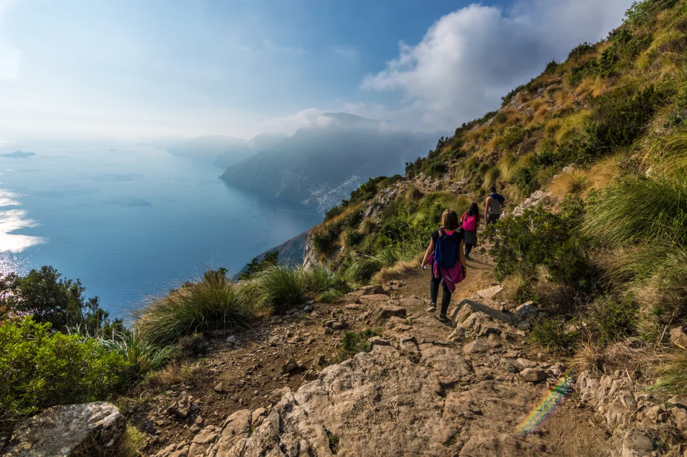
    The route alternates between earth, stones, steps and narrow sections. Grippy soles and experience on uneven terrain matter more than distance alone.

    Wear walking shoes with good grip; avoid sandals and smooth soles.

  2. CAI hiking grade E

    The CAI rates the trail E, for hiking. A regular walker can complete it in good conditions, but the exposed sections require confidence. It is not wheelchair accessible or suitable for pushchairs.

    A guide can help organise the walk and explain the route, but the exposed sections remain.

  3. Allow time for transport

    Two hours of theoretical walking time excludes bus waits, breaks and the descent from Nocelle. From Naples or Sorrento, set aside a larger part of the day.

    Check the last return service you can catch before deciding when to start.

  4. Little shade on the trail

    Bring water, a hat, sun protection and a charged phone. Between the villages, do not rely on finding a shop to replace anything you have forgotten.

    In summer, start early and avoid the hottest hours.

At Nocelle: bus to Positano, steps or walking back?
View from Nocelle Ugeorge — CC BY-SA 3.0

At Nocelle: bus to Positano, steps or walking back?

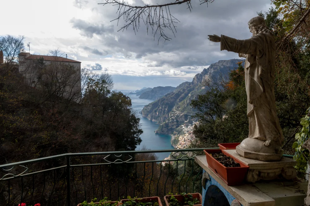
The local bus to Positano avoids the long descent by steps. Check times before setting out and allow for a wait. Nocelle is above the centre, some distance from the quay and ferry departures.

Walking down adds around 1,700 steps. They lead towards Arienzo; a stretch of road then takes you to the centre. This is additional to the 5.3 km Bomerano–Nocelle hike and hard on the knees afterwards. Going via Montepertuso is another extension to plan separately.

From Positano, you can reach Amalfi by coastal bus or ferry when running, then take SITA route 5080 to Agerola if you need to return to Bomerano. For Sorrento, choose the coastal bus or an available ferry. Plan these connections before walking: the return is not a simple shuttle between the trail’s two ends.

How do you reach Bomerano from Amalfi, Positano or Sorrento?

How do you reach Bomerano from Amalfi, Positano or Sorrento? Stiflele — CC BY-SA 4.0

From Amalfi, SITA route 5080 climbs to Agerola. Get off at Bomerano and walk to Piazza Paolo Capasso. From Positano, public transport usually involves changing in Amalfi. Find the day’s timetable on the official route 5080 page.

How do you reach Bomerano from Amalfi, Positano or Sorrento? Stiflele — CC BY-SA 4.0

Travelmar also offers a ferry and shuttle to Bomerano. This combination depends on connections and bookable departures. From Sorrento, excursions with transfers avoid several connections; choose one from the booking cards.

How do you reach Bomerano from Amalfi, Positano or Sorrento? Porfirio from Procida, Italy — CC BY 2.0

If driving, plan how to return to the start. Your car will remain in Bomerano while you finish in Nocelle. The loop via Positano and Amalfi takes time; a transfer may be more practical than a succession of buses after the hike. Parking near the square is not included in trail access.

Fear of heights, weather and maintenance: when should you choose another outing?

If you have a strong fear of heights, the views may become distressing. Some sections run beside steep drops, without continuous barriers. A less exposed branch does not remove all the steep terrain. A viewpoint accessible from a village may be more enjoyable than a hike spent feeling tense.

Postpone the walk during thunderstorms, heavy rain or strong winds. Slippery ground and exposed sections leave little margin for error. After bad weather, local notices may report damage or restrictions even if the sky has cleared.

Follow waymarks and any diversions on the ground. Agerola has published a maintenance notice with an alternative route, but it does not tell you what every section will be like on the day you walk. Check information from the municipalities and CAI before departure. For ideas for another day out on the coast, see our Positano guide.

Which season is best for the Path of the Gods?

Spring and autumn temperatures are often better suited to walking. Keep your itinerary flexible, though: rain or thunderstorms may mean moving the hike to another day.

In summer, start early. Shade is limited, coastal buses fill up, and waiting on the return adds to tiredness. Bring enough water before leaving the villages.

In winter, choose settled weather and finish before dark. Days are shorter, and some ferries or organised excursions do not run. Plan a return by road and follow notices about trail conditions.

Can you walk the Path of the Gods as an out-and-back route?

Yes, returning along the same path gets you back to Bomerano without arranging the transport loop. The out-and-back distance is then around 10.6 km, excluding detours and walking within the villages. Double your planned walking time, then add breaks.

The return climbs towards Bomerano after the mostly downhill outward route. This option suits experienced walkers with enough daylight and water. For a first visit, walking one way from Bomerano to Nocelle with a planned bus return is often more enjoyable.

Location and access

📍 Piazza Paolo Capasso, Bomerano, 80051 Agerola NA, Italie

By car

Head to Bomerano and Piazza Paolo Capasso, but plan for a linear route: your car stays at the start while you finish in Nocelle. The return requires a local bus to Positano, then a SITA bus or ferry to Amalfi, followed by SITA route 5080 to Agerola.

En transports

From Amalfi, take official SITA route 5080 towards Agerola and get off at Bomerano. Travelmar also sells ferry-and-shuttle connections to the start. From Nocelle, reach Positano by local bus or around 1,700 steps downhill; check SITA, local bus and ferry times for the day.

Stationnement

There is parking around Bomerano, but you should not assume a space will be available or that it will be free. The main issue is getting back to a car left at the start; use public transport or a transfer if you want to avoid the loop via Amalfi.

Accessibility

The route is not wheelchair accessible or suitable for pushchairs: uneven ground, steps, rocks, climbs, descents, exposed sections and a sloping exit from Nocelle. Anyone with a strong fear of heights should choose another activity.

Conseils pour la visite

  1. Start in Bomerano

    Towards Nocelle the route is downhill overall, though not continuously.

  2. Check weather and notices

    A local restriction or alert may require you to change or postpone your departure.

  3. Save the map offline

    Use the CAI information and follow signs on the ground.

  4. Bring your water

    Take sun protection and a charged phone too.

  5. Plan how to leave Nocelle

    The bus avoids the roughly 1,700 steps towards Arienzo.

  6. Allow a margin for the return

    The 2–3 hours of walking exclude breaks and transport.

Mistakes to avoid

Confusing Nocelle with Positano

The trail ends in the upper hamlet of Nocelle. The bus or steps down to Positano come afterwards.

Treating net elevation loss as the whole effort

The climbs and descents add up: the CAI route lists 184 m ascent and 356 m descent from Bomerano to Nocelle.

Assuming a short distance means an easy stroll

Uneven ground and exposed sections require suitable shoes, sure footing and confidence with heights.

Following an old GPS track despite a sign

A local diversion or restriction takes precedence over the route saved on your phone.

Starting late in winter or in unsettled weather

Allow time to walk, leave Nocelle and reach your return transport before dark.

Forgetting the journey back to your car

Returning to Bomerano may require several connections; plan it before leaving your vehicle at the start.

FAQ

Route and difficulty

How long is the Path of the Gods?

CAI trail 327 between Bomerano and Nocelle is 5.3 km long. The steps or road down to Positano add to this distance.

How long does the walk take?

The CAI gives a theoretical walking time of 2 hours. Allow 2–3 hours for a sightseeing hike, then add breaks and transport; it soon becomes a half-day outing.

What is the elevation change between Bomerano and Nocelle?

In this direction, the CAI lists a total ascent of 184 m and descent of 356 m. The trail is downhill overall, with uphill sections along the way.

Direction and safety

Which direction should I walk the Path of the Gods?

Bomerano to Nocelle is recommended: it runs downhill overall towards the hills above Positano. The reverse direction is possible, with more climbing.

Can I walk it if I am afraid of heights?

The exposed sections can be distressing for anyone with a strong fear of heights. Variant 327a is less exposed, but does not guarantee a comfortable route for everyone sensitive to steep drops.

Is the trail suitable for children?

It requires sure footing and constant supervision on exposed sections. Ability on uneven terrain matters more than distance alone. Pushchairs are unsuitable.

Access and return transport

How do I reach the start from Amalfi?

SITA route 5080 serves Agerola. Get off at Bomerano, then walk to Piazza Paolo Capasso. Timetables vary by day and season.

How do I reach Bomerano from Positano?

Public transport usually involves changing at Amalfi, then taking route 5080 towards Agerola. An organised transfer can avoid this loop.

How do I return from Nocelle?

Take the local bus to Positano or add the walk downhill. From Positano, continue towards your accommodation; returning to Bomerano often involves Amalfi.

Season and booking

Can you hike in winter?

The path has no ticket-office hours, but you need settled weather, an authorised route and enough daylight. Plan a road-based return, as ferries and guided trips may be reduced.

Do I need to pay or book a guide?

Walking access is free and a guide is not compulsory. Guided hikes and their transfers are separate paid services; the selected tours run seasonally.

How can I check whether maintenance affects the route?

Check notices from Agerola and Positano and the CAI trail page before departure. On the ground, follow waymarks, diversions and posted restrictions.